Sunday 22 September 2013

Eating at the Summer Isles Bar.

I said in the previous post that our interest in the Summer Isles was largely rooted in the shore that overlooks them, and this is unquestionably true.

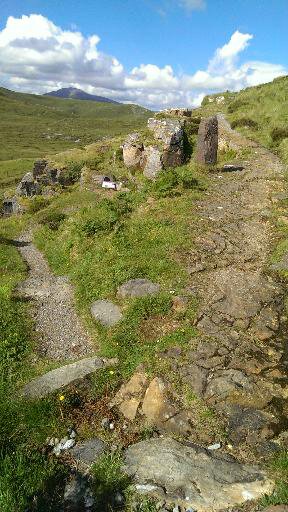
At the end of that last edition we were just approaching the village of Achiltiebuie - our ultimate destination. Achiltiebuie is much larger now than it was on our first visit back in the mid nineties. There are a lot more houses, a piping school and an excellent village hall which plays host to a regular display of local art and crafts. Sadly it's biggest tourist attraction, the Hydroponicom has been closed for some years and now presents a sorry and semi derelict face to the world.

This is a shame, because the Hydroponicom was awesome. Essentially a massive greenhouse using hydroponic technology to grow all manner of food plants you wouldn't normally expect to find at such northerly latitudes. Amongst the salad crops, fruits and vegetables could be found all manner of exotica - including Bananas! The place also incorporated an exhibition of green technologies and was a genuinely fascinating place to visit. It also provided fresh produce to the Summer Isles Hotel - a vital service in a part of the world where fresh vegetables are still annoyingly hard to come by at times, let alone things like salad leaves that perish quickly.

Well, the Hydroponicom may well be defunct, but the Summer Isles Hotel is still going strong, as is the attached Summer Isles Bar. For us a trip to this area isn't complete until we've eaten here, which means that although there is often a long time between visits we've been coming here regularly for damn near twenty years.

The bar is actually very small, consisting of two rooms that for now I'll call "compact", because calling them "poky" sounds derogatory and I love this place too much to say anything that might sound negative. The bar was originally built in the nineteenth century as a watering hole for local crofters, and has apparently been extended over the last forty years - although if this is the case I can only imagine how snug it must've been back in the day...

You enter through a small porch into the "front room", which boasts patio doors which rather predictably look out onto  a small patio area and the view beyond. These days this room is furnished with dark wood dining tables and chair, and is light and cosy although I rather miss the high backed wooden pew-like arrangements that used to occupy this space to form little booth type areas. Still, there's more room for more people now, and fair's fair - a place as good as this really ought to be able to accommodate as many people as possible.

Beyond this is the bar itself, a small room with an inviting fire and walls covered in pictures of days gone by. There are now windows in this area, all the light coming either from the patio doors in the front section or from lamps. This could make things seem a little gloomy, but actually just gives the place a more intimate feeling.

We actually arrived only just after noon, and both rooms were empty when we entered. We grabbed seats at a table near the patio doors and I wandered into the bar to order drinks and grab a couple of menus. The bar always has an interesting selection of beers brewed in the Highlands, and I think perhaps my only beef with this fantastic little pub is the fact that it sits at the end of a long, narrow and winding road and whenever we visit I'm always driving, which means I can never sample any of them.

I took Mrs Snail's glass of wine and my Coke back to the table and we perused the menu.  The bar is famous rightly for it's seafood, and no review could fail to omit mention of their astonishing seafood platter. For a little bit short of twenty five quid you will be provided with a plate size of a small island piled high with local langoustines, smoked salmon, pickled herring, shellfish and whatever else happens to be in season. It is a sight to behold, let me tell you.

Personally I don't like seafood much, so would never consider such a thing. Mrs Snail loves seafood, and would probably order one every time we came. Sadly, presumably because the culinary gods have a profoundly sick sense of humour she has developed an allergy to shellfish and crustaceans like prawns and langoustines which means the delights of the seafood platter are off limits. One time we were there, she stared so longingly at a neighbouring diner's lunch he actually offered her a langoustine. It really is that good.

But as I say, not for either of us, so Mrs Snail opted for the duo of smoked salmon, and in the absence of my usual burger (the bar is too classy for that) I went for a steak sandwich, which in many ways is the same thing, but in a purer form. There was a little discussion as the waiting staff realised that they didn't have any of the grain mustard mentioned in the menu and wondered whether I'd be happy with English mustard instead.

I assured them I didn't care, and was rewarded with a brown baguette filled with fried steak and onions. There was some side salad nonsense of course, but I'm from Yorkshire, so I ignored it. It was truly lovely. If anything, Mrs Snails smoked salmon duo was even better. Basically her plate was laden with two massive piles of smoked fish, one hot smoked, one cold. Cold smoked salmon leaves me, well, cold. I've never seen much attraction in what is, essentially, raw fish*.

Hot smoked salmon however is one of my very favourite things, however and to my delight the massive piles of piscatorial delight were to big for Mrs Snail to manage so I was able to purloin rather a lot of the hot smoked pile.

It. Was. Astonishing.

Soft and moist on the tongue with that wonderful kick of smoke, it was fish to fall in love with. 

The sky had been looking rather threatening when we arrived (I confess that the picture above was taken as we left) but by the time we'd eaten our lunch the sun was shining so we took the opportunity to adjourn to the patio for coffee. We sat for a while looking out over the stunningly blue sea, 
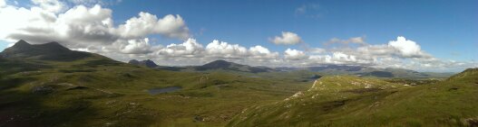
out towards the island of Tanera Mor.

As I mentioned in the last post this is the only inhabited island in the Summer Isles, and at the time we were there (August 2013) it was up for sale with an asking price of £2.6 million. I have to say, if I had that kind of money burning a hole in my pocket I'd be making an offer. I've always wanted to live on an island, and an island in such close proximity to such a wonderful eaterie? What could be better?

Of course, from the patio the view is somewhat obscured by the trees that run along the hotel's fence. So, take a look at the panorama you'll see from the beer garden:


Beautiful, isn't it? And the view is always this good. Not always this blue, I'll grant you, but when the weather is poor it just gets more dramatic, not less beautiful.

You really should go.


*Yes, I know, technically it isn't raw because the smoke cures it. But in terms of texture and appearance there is no difference between cold smoked salmon and a slice off a salmon you just dragged out of a stream. Prometheous stole fire from the gods and ended up getting his liver eaten by eagles for all eternity so that we could cook stuff. Given that, it seems rude not to.

Saturday 21 September 2013

Making our way to the Summer Isles

The Summer Isles are made up of a seemingly endless number of tiny pinpricks of land to the north of Loch Broom, off the coast of Coigach. 

Only one, Tanera Mor, is inhabited and is perhaps best known for issuing its own postage stamps - something it's done since nineteen seventy. Given that according to the 2001 census only five people live on this roadless three and a half kilometre square lump of torrodonian sandstone I've never been entirely sure how they've kept the post office staffed, but fortunately such issues happen above my pay grade so I've never really worried about it. 

We've often gazed across the waters of the Minch and considered paying it a visit, but somehow have never quite managed to actually do it. One day, perhaps...

The truth is our interest in these islands is firmly rooted on the shore that overlooks them - but more of that later.

If you're not approaching by sea, there are only two routes in to the isolated little enclave of villages that occupy the mainland shore beneath the shadow of Ben More Coigach and Stac Pollaigh.You can take the narrow, single track twisty road that runs out of Lochinver, past the Culag woods, the school and Loch Culag, or you can take the narrow, single track, twisty road that branches off the A835 about half way between Ullapool and Elphin, with Cul Baeg and Stac Pollaigh on your right and Ben More Coigaich on your left.

Either way, the scenery is spectacular and the road is easier than you'd imagine. I've said this before, but I've never understood why some people have an issue with single track roads - all you have to do is drive at a sensible speed and pay attention to what's in front of you and what's coming up behind. Things that you should be doing anyway if you're behind the wheel of a car.

So.

The little twisty road winds its way along the northern shore of Loch Gurlainn, on the other side of which stands the lumpen mass of Ben Mor Coigach - all seven hundred and forty three metres of it. Like many big hills in, poor old Ben Mor doesn't look all that impressive. It is, essentially a big rolling rounded lump. As you approach the end of Loch Lurgainn the more diminutive Stac Polliagh (a whole ninety metres shorter) sits demurely on your right, presenting a far more interesting vista.

There's a fairly sizable car park at the base of Stac Pollaigh (it's pronounced "Stak Polly") should you wish to make the ascent. I've never climbed it - but am assured that the summit requires rather a lot of rock scrambling which pretty much guarantees I never will. I'm a hill walker, not a mountaineer, the distinction being that I rather like have solid ground beneath my feet and clinging to a rock face doesn't appeal in any way...

If you feel the same way, eschew the charms of the Stac Polliagh ascent  and bypass the car park you'll leave Loch Lurrigann behind and almost immediately find yourself with the wider but shorter Loch Bad a Ghaill taking its place on your left hand side. To your right you'll catch some views of the sea looking north towards Stoer Point and it's lighthouse, then the road begins to climb and the sea disappears, before reappearing briefly as you descend once more to a "T" Junction. Just before the junction there is a spectacular view out over saltmarsh to a wonderful golden sandy beach and the crystal blue sea of Achnahaird Bay beyond.

It's worth stopping to take a look - especially if the weather is good, because this photograph utterly fails to do it anything approaching justice:

 Honestly. It looks spectacular when you're there.

 Turn right at the junction here and you can gain access to the beach a few hundred yards down the road just turn right when you see the little sign marked "to the beach" - it's a dead giveaway. It's a good beach, provided with more than ample car parking, from which you have access not only to the beach but also to a couple of pleasant footpaths, should you fancy a walk.

Continue on this road and you'll make a loop the two hundred and three metre lump of Mael an Fheadain - the road offering some impressive views to the north, although very few places to stop and enjoy them unless you're walking or cycling. As of 2012 there's a camping and caravan site along here, just outside the little settlement (it really is too small for me to call it a village) of Althandhu. It's a smart and well appointed little place, offering excellent views, great walking and access to the beach. We've never stayed there, but we probably will at some point.

As a point of information I should point out that the Camping and Caravan site marked on my copy of the local OS map by the beach at Achnahaird has been closed for some time, so if you fancy pitching up in this neck of the woods you'll need to keep going for a bit. There are a fair few self catering chalets around Altandhu as well, so there are plenty of opportunities to linger.

Altandhu is also where you'll find what used to be called the "Achiltiebuie Smokehouse", but now seems to have rebranded itself "Summer Isles Foods" - a rebranding which makes sense because while you can see some of the Summer Isles from their car park, you are manifestly not in Achiltiebuie. Here they smoke all manner of local seafood, and operate a little shop which sells not only their own wares, but also high quality stuff from other local producers.

It's a lovely place. You can't take a tour of the production line as such, but since production takes place in what are basically a couple of big sheds, there are huge windows you can peer through, with signboards outside explaining what is going on at each stage. In this pre-packed world, it is very nice indeed to see real food being made. Also, you can stand under the vent from the smoke room and breathe in the awesome smell. Honestly, two or three lungfuls of that are worth the trip ontheir own.

As you leave Altandhu the road begins to climb, and after about a quarter of a mile you have an opportunity to make a hard right turn down to the little harbour at Old Dornie. Nobody lives down there, but there is a very sheltered harbour, protected by the bulk of Isle Ristol - one of the largest of the Summer Isles, and on a sunny day it's a wonderful place to stop for a picnic.

Carry straight on and the road sweeps you on to Polbain - which is basically a street with houses strung along it like gems on a necklace - a tiny settlement posessed of one of the finest village stores we have ever seen. I have no idea how they fit everything in, but there is very little you might need that they don't have.

Beyond Polbain the road sweeps back down to sea level, and then back up towards Achiltiebuie, another sort of "necklace village" which has grown rather a lot since we first ventured down here in the nineties. Achiltiebuie is home to the object of our visit to the Summer Isles, and that my friends is the subject of the next post.


Sunday 8 September 2013

A walk around Knockan Crag - the heart of the North West Highland Geopark!

I mentioned in an earlier post that geology is important in Assynt, and I've already made an oblique reference to The Rock Route, a driving trail that takes the curious motorist around this unique geological landscape. There are laybys at geologically interesting points, equipped with informative signboards which explain clearly what you're looking at, and why it's important. Indeed, Assynt is part of the North West Highlands Geopark, the centerpiece of which is the excellent visitor centre at Knockan Crag.

This is perhaps my favourite visitor's centre anywhere, mostly because it is so well done, and so utterly appropriate. You see, one of the reasons we love this part of the world is the opportunity it provides for solitude and for getting away from the routine imposed by clocks, timetables and opening times. Well, the Crag is a visitor centre which you can have totally to yourself if you turn up at a quiet time because it has absolutely no staff. As a by product of this it's open twenty four hours a day, fifty two weeks of the year. Turn up and experience it whenever you want - although as you'll see, it might not be a good idea to turn up in the pitch black or in really bad weather...

Knockan Crag is about a mile south of the little Certificated Location we were pitched up on in Elphin, so after a day of vehicular exploration around the wider area I took myself for a little stroll around this geological showcase.

Even from the car park the view is spectacular, looking out across the water, between Cul Mor and Cul Baeg, towards the rocky peak of Stac Pollaidh in the distance.

Looking up the hill from there you can see the little turf roofed shelter that houses the main exhibition. This part of the trail is wheelchair accessible, and fine for people with other mobility issues, I'm afraid that the rest of the crag probably is not...

This is in fact a fairly new exhibition, the centre was refurbished and renovated a few years ago (and indeed in the great Highland spirit of recycling some of the large sign boards from the old display can be seen serving as the walls of a sheep shed in Elphin) and the whole thing is now very slick and interactive.

You're met initially at the entrance to the little eco shelter by bronze statues of legendary geologists Ben Peach (seated) and John Horne (standing). If you're unfamiliar with these names and have never heard of their achievements in geological theory, don't worry - this is also where the interaction starts.

By the side of Ben Peach's seat (which is large enough for you to share with him and offers a pretty cool photo opportunity) is a set of buttons marked with national flags. Push the flag most closely associated with your language and Messers Peach and Horne will tell you a little bit about themselves, in whatever language you prefer.

Basically- and real geologists will need to forgive me here because I'm going to massively over simplify this - Peach and Horne figured something out that revolutionised our understanding of geology and the way the Earth's crust as we know it today was formed. Before the work they carried out in Assynt the standard view was the fairly logical assumption was that new rocks were laid down on top of old rocks. This "layer cake" idea makes perfect sense and allowed geologists to date the rocks they were looking at.

So far, so straight forward.

The trouble was that here in Assynt some of the oldest rocks in the world are sitting on top of rocks that are much younger and to the nineteenth and early twentieth century geologists this simply didn't make any sense at all. Peach and Horne worked out the solution, and changed the outlook of the science of geology forever. 

In 1907 they identified the "Moine Thrust", a geological feature that runs all the way from Loch Eribol on the North Coast of Scotland, through Assynt and down to Sleat on the Isle of Skye. They showed that the thrust forced one older sheet of rock over the top of a much younger series, masking the geology beneath. Small "windows" in the top plate allow geologists to estimate what the previous geology was like. Assynt is one such window, and through it you can see a great chasm of time.
 
 Inside the little turf roofed gazebo there are many displays and interactive thingamiebobs to help explain what all the different rocks are hereabouts, how they formed, what they're called, where you'll find them and how old they are.

There's also a rather wonderful display around the edge showing the horizon in opaque perspex. Each of the visible hills is not only identified, but the meaning of each of the hill's names is explained. Even better, given that most of the names of landscape features in Assynt have their origins in Gaelic, which has a very different spelling system, you can push a button and have a voice pronounce each of the names correctly.

Turns out I've been mis-pronouncing some of them for years, although I feel safe in the knowledge that I'm not alone in this...

If you step through the eco-gazeebo, on the other side you will find a well made path heading off up the edge of the crag, and a bronze statue of a geologist encouraging you to see where it may lead. Anyone with two functional legs and a moderate amount of fitness can follow from here, but by its very nature the terrain beyond this point is unsuitable for people with mobility difficulties and is absolutely not wheelchair friendly. If you suffer from vertigo you might also want to give this a miss - there are some steep climbs with even steeper drops on one side.

Everybody else, follow me - this is a spectacular journey through time and landscape.
You follow the path along the side of the hill and before long you come across a fork. The right hand fork takes you on the rest of the walk, the left hand takes you down a short dead end where two inscribed slabs give you information about fossilised deep sea worms that can be found here, a few hundred feet above sea level. 
Yet more evidence that the landscape of today is radically different from the landscape of the past.

Make your way back to the main path, and there's another carved stone showing what the worms would have looked like, swishing around in shallow tropical seas so many millennia ago.
 The path leads you through a geological timeline for the rocks in these parts, all the time ever so gently taking you higher and higher. The path at this point is not steep, but the drop to your left does keep getting increasingly pronounced. People with vertigo might want to hang on to a companion, or stare fixedly up the hill at this point - although if heights really are a problem for you be warned - it's only going to get worse from here. Trust me though, the views are unquestionably worth it - they really are spectacular!
As the trail leads you further up the hill you are treated to many features created out of the rock that forms this amazing landscape. If you look up from the timeline section of the trail you'll see a perfectly formed stone sphere constructed in the manner of a dry stone wall. It sits on the side of the hill without explanation. I have no idea what it demonstrates, but it looks extraordinarily cool.
Other - what shall I call them? Exhibits, I guess - are more informative than decorative, although there is a strong and pleasing sense of  design throughout the crag. The two stone hands pictured here illustrate the difference between the sandy coloured rock at the bottom and the grey coloured rock above. Place one hand on each, you are told, and you are spanning three hundred million years of history.

Seriously, where else can you go and hold three hundred million years between your hands? 
Eventually the path takes you up a steepish set of stone steps. Again, care is required - it's not in any way a difficult climb, but at the same time you need to remember that the consequences of a fall could well involve dropping a few hundred feet to the road below - something which I suspect would be less than fun.
As you climb you'll want to keep your eye on the view though, because the higher you get, the more you can see. Once you reach the top you are rewarded with an utterly spectacular viewpoint offering views across Assynt and Coigach and beyond. Truly spectacular they must be seen to be believed.
I mean, look at it - have you ever seen anything more beautiful? Here you're looking out towards Lochinver with Cul Mor at the far left, the long ridge of Suilven in the distance just to the right of it and Canisp more or less in the middle of the image. Under blue August skies I honestly could have sat there all day watching the shadows of the clouds scoot across the hills and valleys.
From the viewpoint the path takes you along the top of the crag. The views are amazing, but you do become aware that you're at the top of a hill. On the day I was there the wind was blowing pretty fiercely and I was obliged to remove my hat* because if I hadn't it would currently still be flying somewhere in the jetstream.

The path takes you back along the top of the crag until you are more or less above the car park, and then begins to descend. There is one final viewpoint, looking out towards Coigach with the distant hill Stac Polliagh framed once more in the "V" formed by Cul Baeg and Cul Mor.
The flat triangular stone in the foreground of this picture is inscribed with the words of acclaimed Scottish poet Norman MacCaig:
"I don't remember the Eagle going away
but I'll never forget the Eagle shaped space it left
stamped on the air."
   
Reading those words and looking at that view, I could feel the eagle shaped space in the air. Assynt is a wild, wild place and from this vantage point you can really appreciate that without all the hassle of day long walks and cumbersome walking gear.
But it was getting late, so I began the descent back to the car, knowing that the following day we'd be pointing the car towards Coigach and getting deep into that landscape.

*Rather a big thing from my point of view - I am seldom seen without a hat.


Tuesday 3 September 2013

Lochinver.


Lochinver is a very special place. It's a long way from anywhere, literally at the end of the road. The stereotype would be that it's a quiet, sleepy little place - and as ever the stereotype would be largely wrong.

Not entirely wrong. Lochinver and its surroundings can indeed offer all the peace and quiet you could possibly eat. Culag Woods, on the southern shore of Loch Inver is a case in point. There are forty hectares of mixed woodland here, with beautifully constructed paths, an extremely impressive viewpoint, carved stones and all manner of interesting things. On a sunny day you can stroll through the dappled shade and soak in the peace and quiet. The Culag Community Woodland Trust which manages the wood and holds them under a fifty year lease from the Assynt Estate and the Highland Council, has provided all manner of interesting and entertaining things to attract your attention. There are forty hectares of mixed woodland here, with beautifully constructed paths, an extremely impressive viewpoint, carved stones and all manner of interesting things - including the largest Heronery in Britain.  

On a rainy day, you can do the same thing, it's no less interesting, just wetter...

Culag woods is a good example of the spirit of the people of the area though - it's a long way from being the only community run resource hereabouts, about which more later.

Lochinver's main reason for existing has traditionally been fishing, although unlike most fishing communities the town doesn't cluster around the harbour, rather it sits next to it.

 The harbour divides into two parts, which I think of as "the big bit" and "the marina". I suspect they have proper names, but I've never known them. Pictured here is "the marina", where the smaller boats tie up, as seen from the end of the harbour wall. It seems to me that this section of the harbour has become increasingly busy over the last few years as tourism has become a much more important plank in the harbour's economy.


The trees on the right are Culag wood, and the strange dome shaped thing in the middle of the horizon is my favourite hill, Suilven. As you can see, from Lochinver this massive hunk of Torrodonian sandstone looks pretty much unclimbable, which is perhaps one of the things I love about it.

In fact, probably the most difficult thing about climbing Suilven is actually getting to it. The ascent is actually rather straightforward, although pretty steep, but whichever route you choose it's at least an eight mile walk from the nearest road.

To my eternal regret I've only climbed it once (so far at least) and I don't have any pictures from the top, so you'll have to take my word for it that the view across the Inverpolly estate is spectacular, although actually perhaps the most entertaining thing at the top of Suilven is the summit itself because it's so incongruous.

For a start, from Lochinver - which was the first view of the hill I ever had - you can't tell that the mountain is in fact a ridge about two thousand meters long. The main summit, known as "Caistel Liath" (Gaelic for "Grey Castle") is at the end you can see from Lochinver, and from here you'd  imagine it to be a dome shaped mound. In fact when you're up there the impression you get is of a large cricket pitch with a trig point in the middle - you get very little impression of slope. The middle section, which I've always thought of as "the saddle", although I have no idea why, is known as "Meall Meadhonach, gaelic for "middle round hill" and the minor peak at the south eastern end of the ridge is known as "Meall Baeg", or "little round hill". I can't imagine why, since neither of them are round, but it makes a change from another variation on "Ben Mor", so I'll let them off.

The most whimsical thing about Suilven however is the fact that, after you've climbed the impossibly steep but surprisingly easygoing slope up to Meall Meadhonach from the southwest - which is the easiest ascent in my view -you turn left and are immediately greeted by a dry stone wall. With a gate in it. Not even kidding. Well, there's no actual gate, just the space where a garden gate sized gate would fit. More astonishing, the wall doesn't seem to constructed from the reddish torrodonian sandstone that the hill is made of which means that somebody physically lugged what looks like a couple of tonnes of stone up the slope.

To build a wall which separates a bit of empty hill from another bit of empty hill. Honestly, it's worth the climb just for the chance to marvel at the human capacity to achieve amazing, if amazingly pointless, results...

However, I'm not supposed to be telling you about Suilven, I'm supposed to be telling you about Lochinver harbour. So, take a look at the panorama above. It was taken from the end of the main jetty,to the right of the image is the area I referred to earlier as "The Marina" where the pleasure boats and smaller fishing vessels tie up. To the left is the deep water area where the big fishing boats tie up. That two tone beige and brown building is the fish dock/market.

You'll notice that the bit on the right is reasonably full. The bit on the left is not. Back in the nineties when we first started to visit this brilliant town there would be a couple of boats a day tied up here. Now? Not so much, although while we didn't see any boats here this trip either, we did see a lot of massive refrigerated lorries waiting by the fish dock, which is an encouraging sign.

Besides, there's more to the town than fish.

Between the harbour and the town proper stands the Lochinver Mission. This used to be the Fisherman's Mission, owned and operated by the Royal National Mission to Deep Sea Fisherman, and existed to serve the spiritual and pastoral needs of the fishermen who passed through here. As the volume of fishing traffic declined, the number of men requiring the services it offered also declined until there was no point in maintaining a mission to serve them, so it was closed.

So, the people of Lochinver took it over. They spruced it up, and re-opened it. Now it houses a very bright, clean and airy bunkhouse which can sleep up to fifteen people and a fabulous looking cafe offering locally produced food at very reasonable prices. We haven't had chance to eat there yet, but I've not seen a bad review of the place. They're also intending to open a marine life center to showcase the vast array of fishy type things that live in the waters around Assynt.


And if all that weren't enough, the field in front of the mission building plays host to the annual Assynt Highland Games every August. We missed them this year, but we've been to a couple of games and I can honestly say that if you get a chance, you really should go and take a look - or even join in! They won't let you enter the "heavy" events (like the shot, hammer and caber toss) unless they're confident you can do it without killing yourself, but the other events are open to all.

As I said, we didn't make it for the games this year, but I can't resist adding this image of a man throwing a massive iron weight over a bar. We were riveted by this event and I'm still astonished that none of the competitors got hit in the head! This was taken at the 2010 games, and I think the gentleman pictured here was the eventual winner, but extend my apologies if I'm wrong...

If you make your way from the Mission into the centre of the village there is yet more to delight you. Several art/craft shops can be found here selling the work of local artists, and there are many excellent places to grab a bite to eat. We didn't actually eat at any of them this time around, so you'll have to wait at least until our next visit for a full review of anywhere in the village, but since we're passing I feel I should mention a few of our favourites.

For a decent lunch or evening meal you can't fault the excellent Lochinver Larder which offers a range of Cafe and Bistro delights, but particularly excels at pies. From Chicken Curry to Strawberry and Rhubarb,  their handmade pies simply defy description - and if you think the drive to the far north west might be too far, don't worry, because they'll post them to you! Honestly, I'm not in the business of trying to sell you things, but I love these pies.

If you're a serious foodie and are looking for something just that little but special, I can tell you that two of the best meals we have ever eaten were here in Lochinver.

Sitting high above the town the Inver Lodge Hotel offers dinner to non-residents, and the dining room has an absolutely stunning view of the sea loch. Even more impressive - and where we ate what I think probably was the best meal we have ever had -  is The Albanach.

Now. Technically, The Albanach isn't in Lochinver, it's on the other side of the sea loch in the little settlement of Baddidarach, which is where people in Lochinver move to if they find the strain of metropolitan life a little but much. You're a ten minute walk or a three minute car drive from Lochinver centre, so this is a mere technical detail.

We've eaten at the Albanach twice. On each occasion we were asked when we booked whether there was anything we didn't eat. The chef went out of his way to ensure that we weren't served any of the things we specified. Beyond that, there was no menu. We were served whatever it was that was best that day. The very freshest, in season produce from the region. The food was sublime. The service was beyond reproach. The wine list blew my mind (and I know a little about wine - I used to work in the industry). 

Honestly, the meals we have eaten at the Albanach were the most expensive we have ever eaten, but they were also the best value. I cannot recommend the place highly enough - and of course if you happen to be travelling sans caravan you can even stay there. Even better, since our last meal there the Albanach has been awarded a Michelin star - which is not something you'd expect to find in a village that only has one street.

Food, views, and a people who have a firm sense of what's good for their town and then ensure it is preserved - and there are even a couple of things I'm holding back for a future posting! There is a lot to love in this little fishing community at the end of the road...